


0

Hiking itinerary
-
Distance 5.4km
-
Change in altitude (uphill) 178m
-
Departure Talloires-Montmin
-
Duration 02h00
-
Difficulty Very easy
- Maximum altitude 648m
Opening period
All year round.
Subject to favorable snow and weather conditions.
Description
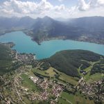
The local nature reserve encompasses a part of the Roc de Chère, a small wooded massif (200 ha) which sticks out on Lake Annecy, between Menthon-Saint-Bernard and Talloires-Montmin.
This territory has been spared from urbanisation and is a remarkable place to discover nature and wonderful panoramas. Its small surface and its rolling topography are perfect for an easy family trip.
Facilities
- Hiking itinerary
Services
- Pets welcome
Price
Free access.
Environment
- Route du golf
- Talloires
- 74290 Talloires-Montmin
Find this route on your smartphone thanks to our ViAnnecy application.
Find this route on our ViAnnecy application