


0

Hiking itinerary
-
Distance 5.3km
-
Change in altitude (uphill) 362m
-
Departure Talloires-Montmin
-
Duration 02h00
-
Difficulty Medium
- Maximum altitude 1485m
Opening period
All year round.
Subject to favorable snow and weather conditions.
Description
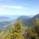
Hike departing from Col de la Forclaz (1,147 metres). Spectacular panoramic view over Lake Annecy and the surrounding mountains: Bauges, Tournette, Dents de Lanfon and Semnoz.
A family-friendly hike. Take walking poles, a camera and sufficient water, especially in summer. Don’t forget your binoculars for observing the wildlife: chamois, ibex and eagles.
The forest sections provide shade in the summer. A superb panorama from the Rocher du Roux viewpoint!
Paragliders can take off from Col de la Forclaz to admire some of the most beautiful views of Lake Annecy!
Facilities
- Hiking itinerary
Services
- Pets welcome
Price
Free access.
- Route du Col de la Forclaz
- Montmin
- 74210 Talloires-Montmin
Find this route on your smartphone thanks to our ViAnnecy application.
Find this route on our ViAnnecy application