


0

Hiking itinerary
-
Distance 10.5km
-
Change in altitude (uphill) 1001m
-
Departure Annecy
-
Duration 04h30
-
Difficulty Hard
- Maximum altitude 1282m
Opening period
All year round.
Subject to favorable snow and weather conditions.
Description
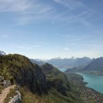
This hike will make you discover some panoramas of Lake Annecy and the old station of the cable car, while going through the Mont Veyrier and Mont Baron. It is a difficult and physical hike which will reward you with beautiful views over the lake, the Aravis range and Bauges Mountains... and the Mont Blanc.
This stroll around the Lake is a must do !
Facilities
- Hiking itinerary
Price
Free access.
- Avenue de Chavoires
- Annecy-le-Vieux
- 74940 Annecy
Find this route on your smartphone thanks to our ViAnnecy application.
Find this route on our ViAnnecy application